SHARE
Urban Heat Islands: Effects on Climate Change and Potential Solutions
Author: Mahbod Shifei. The urban population is increasing all over the world, and consequently, construction occurs to respond to this stunning dwelling. Urban Heat Islands (UHI) are a result of urbanization because of changing the open land vegetation into buildings, roads, and other infrastructure.
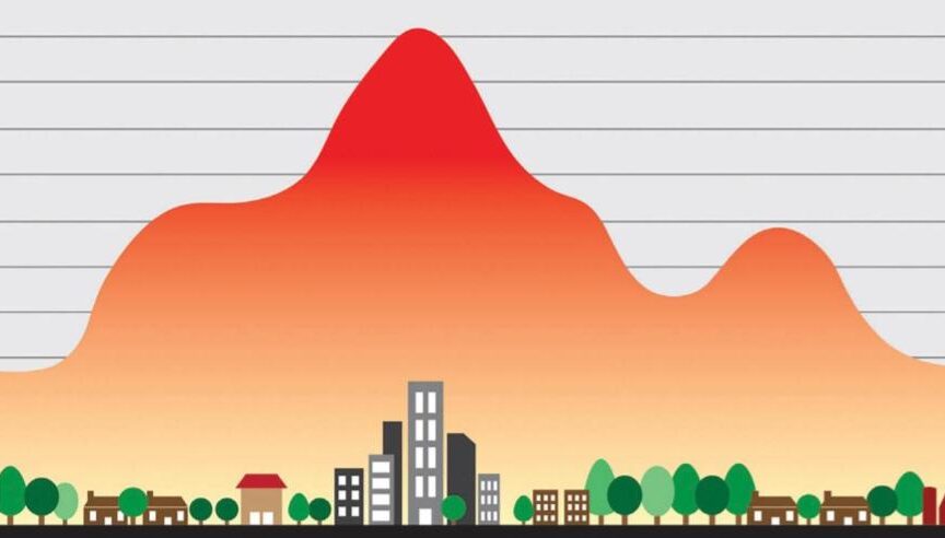
Surfaces that were once permeable and moist generally become impermeable and dry. In this phenomenon, urban regions have warmer temperatures than their rural surroundings. The annual mean air temperature of a city with one million people is 1 ̊C to 3 ̊ C higher than its surroundings. This temperature difference is as much as 12 ̊ C on a clear night.
Summertime urban heat islands are most intense when the sky is clear and winds are calm. In each city, several factors cause the formation of the urban heat islands. Generally, there are some basic parameters that play an important role in the forming of the urban heat islands.
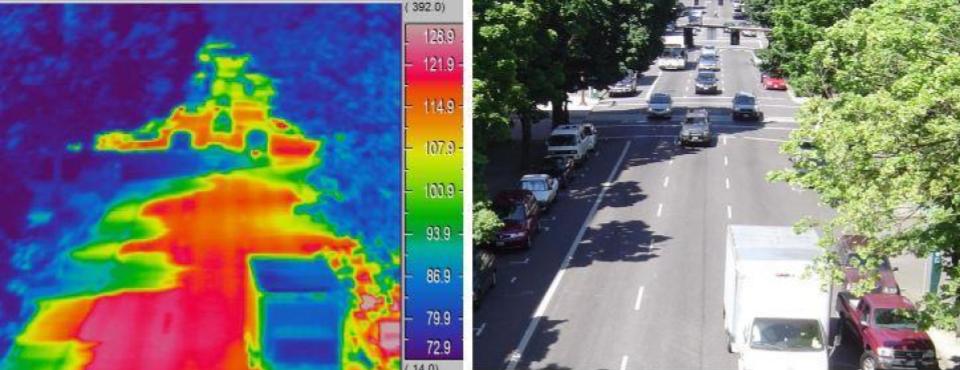 Figure 1: This street photo shows the effect of shade on paved surface temperatures. Surfaces in the shade are 30 to 50 ̊ F cooler than paved surfaces [3].
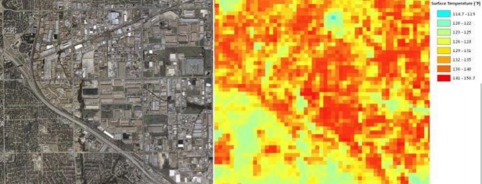 Figure 2: This industrial area illustrates the impact of extensive heat-absorbing pavement and roofing on surface temperatures. The surface temperatures of the residential areas to the southwest are 10 to 20 ̊ F cooler [3].
All things considered, it is necessary to consider the urban heat island influence in the cities. The most effective path to mitigate Urban Heat Islands includes increasing overall city albedo, increasing green areas, and green roofs, and ponds within urban areas, reducing anthropogenic heat inside canopies, and proper designing of the street. These strategies, directly and indirectly, reduces energy consumption and raise the outdoor air quality. Also, to reach these goals, education, research, policies, regulations, and incentives are necessary by governments. If you want to read more about sustainability, energy-saving solutions, and climate-change initiatives, check out ennomotive’s blog and discover what ennomotive can do for you. Join the engineering community References: [1] Eva Wong. Reduction of urban heat islands compendium of strategies. Provided technical and administrative support for the entire compendium and Eastern Research Group, Inc. Developed by the climate protection partnership division in the U.S environmental protection agency office of atmospheric programs. [2] Rajagopalan Priyadarsini, Wong nyuk hien. Causes of Urban Heat Island in Singapore, An investigation using fluid dynamics (CFD). School of Architecture & Building, Deakin University, Geelong, Australia and Department of Building, National University of Singapore, Singapore [3] Dallas Urban heat Island options. Ways to effectively reduce Urban Heat Island effects. The article is prepared by the Houston Advanced Research Center as part of the Dallas sustainable skylines initiatives through the support of the U.S Environmental Protection Agency September 2009.
- Reduced vegetation in urban areas: vegetation helps to release water to the surrounding air and reduce the ambient air with lower surface temperature.
- Properties of urban materials: solar reflectance, thermal emissivity, and heat capacity influence urban heat island development as they determine how the sun’s energy is reflected, emitted, and absorbed. Solar reflectance or albedo is the percentage of solar energy reflected by a surface associated with materials color.
- Urban geometry: the factor that influences urban heat development, notably at night is urban geometry, referring to the dimensions and spacing of buildings within a city. Urban geometry influences wind velocity, energy absorption, and the ability to emit radiation to space. Studies often work on urban geometry called urban canyons, which is a narrow street lined by tall buildings. Tall buildings create shade, reducing surface and air temperature, but when sun energy reaches the canyon surfaces, then reflect and absorb by building walls, lowering the overall canyon albedo and increasing temperature. At night urban canyons block cooling as buildings obstructs the heat released from urban infrastructure.
Modeling and evaluation of Urban Heat Islands
Many studies evaluated the urban heat island around the world to mitigate its side effects. To investigate urban heat islands, researchers use direct and indirect methods such as remote sensing measurements or numerical modeling. In numerical modeling, the urban energy balance equation provides useful information for scientists by balancing the incoming and outgoing energy fluxes. Parameters of the energy equation help to understand the urban heat island development better. These parameters included:- Shortwave radiation is the ultraviolet-visible light from the sun. Urban surfaces reflect less radiation into the atmosphere and store more of it.
- Thermal storage influences by the thermal properties of construction materials and urban geometry.
- Longwave radiation or heat radiates by buildings or other objects that absorbing shortwave radiation, especially at night.
- Latent and sensible heat describes by evaporation of water to humidity and convection of heat between surfaces and air.
- Anthropogenic heat generated by cars, air conditioners, industrial facilities, and other sources.
- Urban geometry in modeling defines as the sky view factor (SVF), which is the visible area of the sky from a given point on the surface.
- Weather and geographic location impact the phenomenon with wind and cloud cover and topography of the city. Large bodies of water can generate winds and moderate temperatures.
Real case study and results
A research study investigated the key factors causing urban heat islands in Singapore due to its low latitude. In this study, airflow in hot spots, the effect of the building geometry, and the location of air conditioning condensers on the outdoor air temperature investigated with computational fluid dynamic (CFD) modeling. The direct measurement shows that building masses increase thermal capacity, reduce wind speed, and radiate heat through the buildings. They model the canyon and canopy layer of the city by describing the long street with tall buildings on both sides. The study focuses on geometry modification because the urban wind dominates by urban design, and urban geometry can cause some short wave radiation, particularly within urban canyons. They establish the model with height, length, and width ratios of buildings because the fundamental urban design elements are the overall density of the urban areas, the tall of the industrial buildings, and the orientation and width of the streets. The results show that a few blocks of high rise towers help to enhance the velocity and lowering the temperature within the canyon when the wind flow is parallel or perpendicular to the canyon. Also, the results show the high temperature at narrow canyons and low temperatures at wider ones. Moreover, the geometry of the neighboring canyons increases the wind speed and decreases the temperature of the narrow street. Air conditioning units spaced widely apart did not contribute much to the heat built up inside a canyon, and close cooling towers affect the immediate surrounding and reduce the capacity of inside units by increasing the ambient temperature around. The results can serve as design guidelines for sustainable urban development to ensure rational energy management and conservation [2].Reducing heat urban island effect in Dallas
In 2009, researchers studied 3 ways to effectively reduce urban heat islands in Dallas:- Expand and protect urban tree cover to help cool the city and improve vegetation features of the canyons. Also, sensor observations show that temperature over the pond maintains a constant temperature day and night.
- Increase roof reflectivity by cool roofing to reflects solar radiation and reduces energy demand for air-conditioned buildings.
- Reduce paving reflectivity by pervious paving, helping to lower area temperatures by increasing evaporation, and benefits water quality by reducing temperature and removing pollutants.
Figure 1: This street photo shows the effect of shade on paved surface temperatures. Surfaces in the shade are 30 to 50 ̊ F cooler than paved surfaces [3]. Figure 2: This industrial area illustrates the impact of extensive heat-absorbing pavement and roofing on surface temperatures. The surface temperatures of the residential areas to the southwest are 10 to 20 ̊ F cooler [3].All things considered, it is necessary to consider the urban heat island influence in the cities. The most effective path to mitigate Urban Heat Islands includes increasing overall city albedo, increasing green areas, and green roofs, and ponds within urban areas, reducing anthropogenic heat inside canopies, and proper designing of the street. These strategies, directly and indirectly, reduces energy consumption and raise the outdoor air quality. Also, to reach these goals, education, research, policies, regulations, and incentives are necessary by governments. If you want to read more about sustainability, energy-saving solutions, and climate-change initiatives, check out ennomotive’s blog and discover what ennomotive can do for you. Join the engineering community References: [1] Eva Wong. Reduction of urban heat islands compendium of strategies. Provided technical and administrative support for the entire compendium and Eastern Research Group, Inc. Developed by the climate protection partnership division in the U.S environmental protection agency office of atmospheric programs. [2] Rajagopalan Priyadarsini, Wong nyuk hien. Causes of Urban Heat Island in Singapore, An investigation using fluid dynamics (CFD). School of Architecture & Building, Deakin University, Geelong, Australia and Department of Building, National University of Singapore, Singapore [3] Dallas Urban heat Island options. Ways to effectively reduce Urban Heat Island effects. The article is prepared by the Houston Advanced Research Center as part of the Dallas sustainable skylines initiatives through the support of the U.S Environmental Protection Agency September 2009.